 |
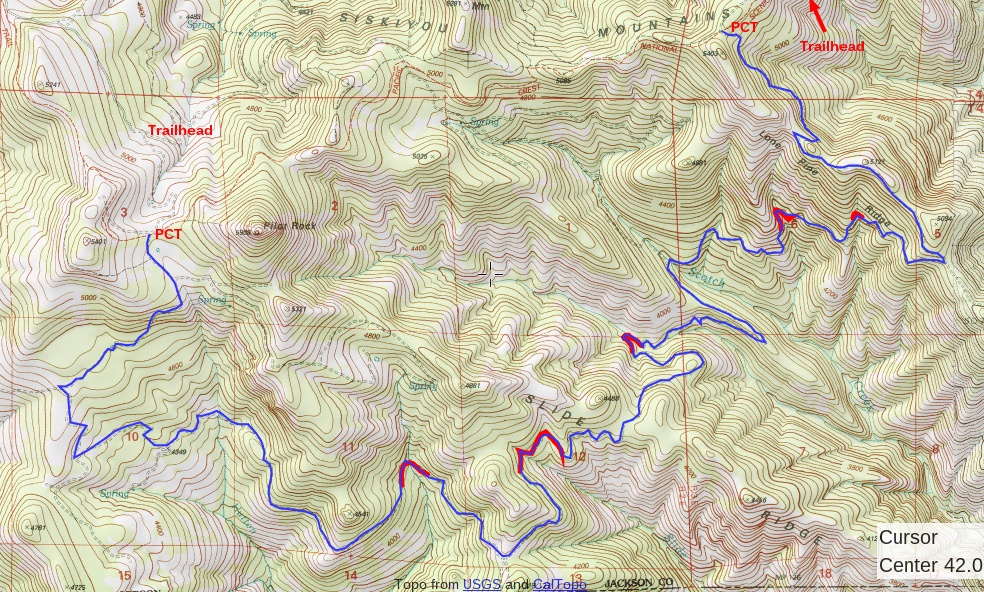
| Blue highlighted section is Lone Pilot Trail |
The gradient is easy, but the hike is long (15.25 miles, map above) and does have more than 2000' elevation gain total. So participants should be in good shape and comfortable with a hike this arduous.
We'll leave Ashland at 7:30am and return by 7pm. Email howegabe@gmail.com or call 541-708-2056 for details and to sign-up.
 |
| Century volunteer Lisa Stutey stands next to an old growth pine bucked to wilderness clearing limits |
The 24,123-acre Soda Mountain Wilderness Area sits barely north of the California border, just east of Ashland, OR.
The Soda Mountain Wilderness was designated in 2009 by Congress, which created a unique mandate for the Bureau of Land Management to return an area that was partially developed to wilderness, a process known as "re-wilding."
 |
| Rolling drain dips had to be out-sloped on a road that was in-sloped |
Part of that process was to incorporate a 12-mile network of roads that connects with the Pacific Crest Trail into the area's trail management system. The route became known as the Lone Pilot Trail. It connects with the PCT near Pilot Rock trailhead, and about 1.5-miles from Baldy Creek Road's terminus.
The route boasts groves of giant Ponderosa pines, open oak chaparral, and towering fir forests. The Soda Mountain Wilderness is where the Cascades, Siskiyous and Klamaths come together, a refuge for wildlife, and harbor of outstanding biodiversity.
The route boasts groves of giant Ponderosa pines, open oak chaparral, and towering fir forests. The Soda Mountain Wilderness is where the Cascades, Siskiyous and Klamaths come together, a refuge for wildlife, and harbor of outstanding biodiversity.
In 2012 the Medford BLM awarded us a grant to convert the old road network to a trail.
 |
| View from Lone Pine Ridge of the Klamath basin |
Work included brushing and logging out of sections of the old road that had overgrown and filled in with trees. We cut everything to clearing limits for wilderness trails. Instead of cutting a log out of the entire road, we bucked out a 2ft-3ft section to allow for hikers and equestrians.
Brush and other debris that didn't overlap into the trail prism was left. Logs and brush we cut were dispersed into the old road corridor.
SMC crews also improved existing drainage features (rolling drain dips), as well as installed new ones in areas threatened by erosion.
 |
| Old growth pine bucked to wilderness clearing limits |
 |
| Fall colors at Hutton Creek's east fork, a camping option for hikers |